I’ve wanted to walk the Isle of Wight Coast Path since I moved to Hampshire a couple of years ago.
It’s not too far from me, it’s a 67 mile loop (we all know I love a loop walk) and the views were said to be incredible. What better place to GetOutside?!
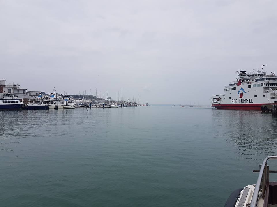
Life has been pretty hectic recently and I needed a break from it all, so thought I may as well get over there and start walking my stress away! So, early on a misty Friday morning I headed for the Red Funnel Ferry in Southampton, embarked and set off for Cowes!
I planned to walk approx 22 miles a day, finishing Sunday evening.
Unfortunately, my knee had other plans… 
Cowes – Tennyson Down

From the Red Funnel Ferry Terminal I headed for the launch across to West Cowes (the floating bridge is out of action until mid May), where it was easy to pick up the signs for the coast path right away. You walk through Cowes Town Centre and out on to the promenade, past the Royal Yacht Squadron gun platform and along to Egypt Point, the northernmost point of the island.
When you reach Princes Esplanade, you continue on to Gurnard, bearing left at the beach huts and following the coast path down through a residential area before emerging on the cliff top above Gurnard Bay.


Some sections of the coast path are diverted slightly here due to erosion of the cliffs, but they are all very well marked and easy to follow.
Make sure you stay away from the edges though as the rock is very unstable.
Eventually you descend on to the beach at Thorness Bay, walk along the shingle and then up the road through the Thorness Bay Holiday Park.
I got a little lost here, it was a total rat run, but I eventually escaped the Holiday Park with the help of OS Maps!


I headed across the fields and then followed the coast path along the main road, dropping down in to Porchfield. From Porchfield you continue along the road to Shalfleet and Yarmouth, in to the village of Locksbridge, where you bear right, following the coast path across the meadows to Newtown.

At this point my knee began to twinge… I dislocated the patella half way up Kilimanjaro in October without realising (thought I’d twisted it), and continued waking to the summit, before then hobbling back down! I’ve been having physio since January so this was my first walk over 10 miles since injury!

From Newtown you walk down the hill and then continue following the (very obvious) blue coast path signs past Shalfleet Mill and in to the village of Shalfleet. This next part was slightly questionable, and I almost got run over on 4 separate occasions as you have to walk along part of the main Yarmouth road (there is a very narrow grassy verge), and people seemingly chose to drive like idiots.
Eventually you meet the coast path again, cross a stile and head across the fields.
Here, I met a chap who was walking the IoW Coast path in reverse and finishing in Cowes. We had a chat and he asked if I was camping, after obviously spotting the huge bag on my back. I said yes, and he said it was a poor life decision and I should have done the same as him, carry a small rucksack and stay in hotels… with gin bars.
I can’t dispute his logic.
You then cross a small inlet and follow the coast path to Lower Hamstead Farm, before heading on to Hamstead Quay and following the river inlet.
The path continues across fields, bridges and a wooden causeway, eventually emerging outside of Hamstead and on through Bouldnor Copse and along Bouldnor Cliff. You reach a shingle beach and walk along this before heading up to the cliff edge again.
Continuing along the marked coast path, you reach the main road, past the viewpoint and walk on to Yarmouth.
|
|
|


Disappointingly, I have no photos of this section between Shalfleet and Yarmouth.My knee was very painful and I just stuck my head down and pushed on the few miles to Yarmouth Harbour, where I stopped for a little cry. My knee was worse walking downhill, and at this point perhaps logic dictates that I should have stopped.
I had a cup of tea, felt sorry for myself and decided to continue as it was only sore on the downhill sections and I knew I could make up time on the flat/uphill parts.


This path follows an old military road along the cliff, with some beautiful views across to Hurst Castle, before heading down through Brambles Chine Holiday Camp. You follow farm track and then Colwell Chine Rd before heading along the sea wall to Totland Pier. Continue following the sea wall and coast path below the top of Headon Warren.
This descent in to The Needles Attraction Park at Alum Bay was excruciating but I knew how close I was and so I took ibuprofen and pushed on.


I won’t stick a photo in here, as I think you have to see it to believe it!!The path then winds round to The Needles Old Battery (definitely worth a visit if you ever head to the Isle of Wight. If only for the wonderful tea and great views!). I was too late upon arrival this time, but I’ve visited before.The Coast Path heads up over the cliff to Tennyson Down here, but I chose to divert and head down to the viewpoint below the Coastguard Station because, frankly, it’s unbeatable…

From The Needles, I headed out past the Coastguard Cottages and down to Stoats Farm, my campsite for the evening. In the field I chose there was just me and one other guy, and it was so quiet. Some running water and somewhere to have a shower was what I needed, as I felt exhausted and my knee was so painful I could barely walk. The last few miles were agonisingly slow and I was probably not even managing 1mph towards the end.
The lady who owns Stoats Farm was wonderful. She got me some painkillers and a Voltarol gel equivalent from her house and it made all the difference!
I made my dinner, got in to my sleeping bag and went to bed, hoping that my knee would feel better in the morning!


Day 2 – Stoats Farm to Freshwater Bay

The next morning my knee was feeling ok. Victory!
I walked off the stiffness and continued on from Stoats Farm, back to the point where I left the Coast Path. I headed up on to Tennyson Down and was rewarded with the best views so far.
If you walk just one part of the Isle of Wight Coast Path, then to walk past The Needles and Tennyson Down would be my advice.


From the Tennyson Monument, you can see across the whole width of the island. It’s a short climb to the top, but well worth it!
Alfred, Lord Tennyson walked on the downs every day and loved the Isle of Wight, composing most of his famous poems as he walked.
The coast path continues along Tennyson Down before dropping down in to Freshwater Bay.


I had the whole beach to myself, aside from a couple of paddleboarders and it turned in to a beautiful warm Saturday!
I stopped for a cup of tea in the beach shelter before continuing on…
I spent a lot of time complaining to various friends on Whatsapp (sorry Jason!) about how I was failing, I wasn’t going to finish the coast path, it was a waste of time.
I sulked, I cried, I called my physio, I complained, and then I realised that actually, it was for the best, and I didn’t want to make my knee injury any worse.

My physio said he’s very happy that I did the walk and tested it as he now knows where we are. The problem was downhill, when I loaded the knee, and so we know to start using weights and strengthen the knee in that way.
Looking back it was a very sensible decision, but I was obviously very disappointed.
I have 37/38 miles left to walk.If you want to follow my Day 1 and Day 2 routes – They’re on OS Maps here and hereThe Isle of Wight Walking Festival starts this weekend, so what better reason to head over and see some of these beautiful views for yourself?!